Project statement
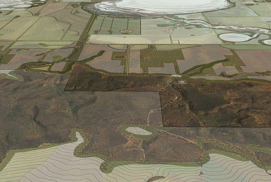
The site for this project is my family’s farm, located in the shire of Wongan-Ballidu in Western Australia. Here in the wheat belt, economies of scale are forcing the amalgamation of traditional family farms within the broadacre agriculture industry. Using a graphic information system and an iterative design process, this project combines emerging precision agricultural theory – including water-use efficiency, yield mapping and controlled traffic farming – with environmental and ecological landscape system design to devise a landscape strategy that could ensure long-term farming viability.
A rigorous mapping process at both farm and regional scales generated an analysis of complex vegetation, hydrology, salinity, geology and agricultural processes and practices. A series of concepts have been generated by combining solutions such as water-use-efficiency yield mapping data and controlled traffic system design to address ongoing problems such as salinity, soil compaction and fragmentation of biodiversity.
This project focuses on increasing agricultural yields while improving the health and resilience of the land, both agricultural and ecological. In harnessing the creativity of a landscape architect in combination with the informed application of innovative agricultural technology and the intimate knowledge of a landowner, a unique pathway towards long-term farming viability is presented.
Source
Award
Published online: 1 Feb 2015
Words:
LandscapeAustralia Editorial Desk
Images:
Christie Stewart
Issue
Landscape Architecture Australia, February 2015